It sounds obvious, but the weather plays a massive role in your experience at the beach. You might think it’s as simple as looking out the window and seeing whether the sun is shining, but there are a few more factors that you should consider before heading to the beach.
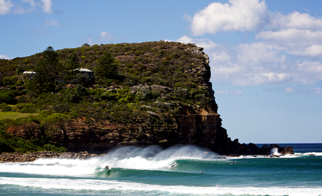
One of the most dynamic features of Australia’s beaches is the waves. They can range from small, crumbling waves gently lapping at the shoreline, to five story monsters that even the greatest surfers fear to ride.
What is the weather like now? Is it sunny? Is it windy? Is there a storm front approaching? What direction is the wind blowing?
All of these questions are important to ask when you’re planning your trip to the beach. The easiest way to check the weather is to check the weather report online, TV, newspaper or radio. That’s where the weather forecast gets interpreted and simplified to give you all the really important information you need to know
An important aspect of the ‘waterman’ culture is being able to interpret the weather. So let’s learn a little about the basics.
The Sun is probably the most important factor that encourages people to get to the beach. A hot day can draw a crowd of over 50,000 people to Australias busiest beaches!
The Australian sun is also famous as being particularly dangerous for our skin. Even on a cloudy day, the sun can cause serious short term skin damage, and long term cancers such as melanoma. To protect yourself; wear sunscreen, sunglasses, a hat, long clothes or rashies and drink plenty of water. You can learn more with the Australian Cancer Council.
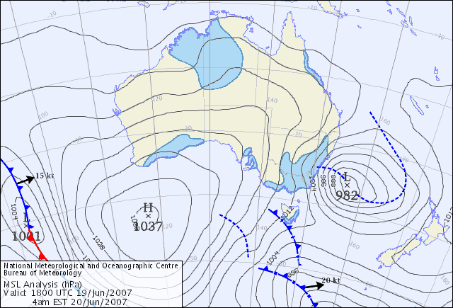
The atmosphere is continually trying to redistribute hot and dense air evenly across the Earth which generates air pressure systems called statistical highs and lows. These can be represented on a map as a synoptic chart. You might have seen these on the nightly TV weather report.
When reading a synoptic map, you’ll see lines which connect areas of equal air pressure. These are generally arranged in circles around either a high or low pressure system. Wind is generated by air moving from areas of high pressure to areas of low pressure. It does this by moving clockwise around low pressure systems, and anticlockwise around high pressure systems. The closer the lines are together, the stronger the wind will be.
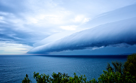
Big swells are commonly generated around intense storms of low pressure. On this synoptic map, you can see a low pressure system off the each coast which generates strong southerly winds up the coast, dangerous surf conditions and heavy rainfall.With a little practice, these charts can help you predict many aspects of the weather at your local beach like wind and wave conditions!
The far north of Australia can experience intense low pressure systems forming over warm tropical waters which drive strong gale force winds. These are called Tropical Cyclones. Tropical cyclones can produce large swells, which can also be accompanied by a storm surge which is a dome of raised water near the centre, or eye, of the cyclone. Storm surges inundate low lying coastal areas causing extensive damage.
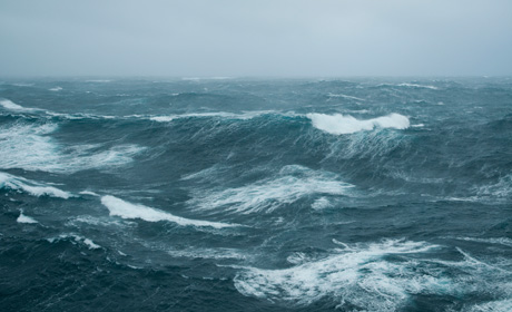
Waves are formed by the wind blowing across the surface of the ocean. Wave genesis usually occurs in intense, stormy low-pressure areas over the ocean.
The size of the waves is determined by three factors:
1. Strength: The intensity of the wind;
2. Duration: The length of time the wind blows; and
3. Fetch: The distance the wind blows.
The longer and stronger the wind blows, the greater the wave action. This process has a direct correlation to the wind produced by large scale weather systems. When these air pressure systems align to produce strong winds, over a long distance, directed at a coastline, you can see very large swell for that specific area of coast. The favourable conditions for that area are sometimes called the ‘swell window’.
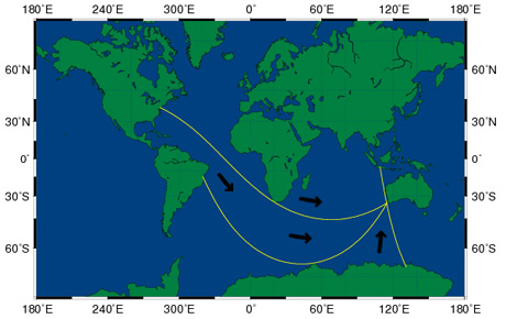
When waves are generated along a path, they follow a single straight line across the oceans until they reach land. These lines are called ‘great circles’. Sometimes, these great circles can result in swells hitting coastline that were generated by systems thousands of kilometers away. These are called ‘long range swells’.
For example, the large swells which hit South Western Australia may originate from the Antarctic Circle south of Africa. Sometimes they are also affected by other systems along the way which can cause the swell to grow or to dissipate, and lose energy.
Occasionally, the winds that occur across the open ocean don’t blow directly onto the shoreline. Local or coastal winds are also affected by the land mass. From time to time, this can result in predictable patterns such as the afternoon seabreeze. Sometimes these become so predictable, that they have their own nicknames such as The Fremantle Doctor- referring to the cool afternoon seabreeze which occurs on hot summer days in Western Australia.
The direction that the wind blows on the coastline will also affect the local surf conditions. Generally, coastal winds are divided into two categories, onshore or offshore.
Onshore winds – blow from the ocean towards the coast. They generally result in cooler temperatures and bumpy, choppy conditions in the water. You can typically see ‘white capping’ of waves to indicate strong onshore conditions. They can also cause marine stingers like bluebottles to wash up on the shoreline.
Offshore winds – blow from the land towards the ocean. These winds generally smooth the ocean surface. These winds are preferred by surfers because the wind assists to prevent a wave from breaking until it reaches slightly shallower water, where it then plunges over itself creating a hollow barrel or tube.
Being able to understand how big the waves will be before you leave your home can save you a trip to the beach or help you choose which beach you will go to, to make the most of the conditions. Surfers do this all the time, and they use some awesome websites which display both the weather and swell conditions.
The coastal zone of Australia is likely to experience significant impacts as a result of climate change in the course of this century, even if the efforts expected from the international community to stabilize atmospheric greenhouse gas concentrations eventuate. This may see an increased frequency of severe weather events, including those which help shape our coastline. This will then affect how Australians use the coast.